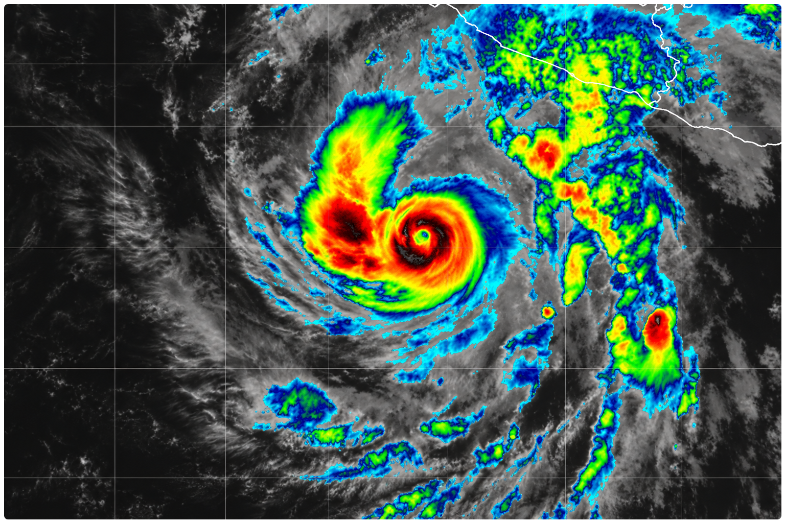
Hurricane Trudy developed a compact, 28-kilometre-wide eye over the eastern Pacific overnight, the visible sign of a storm that had intensified far faster than it was moving. By 3 am local time on Friday, the cyclone was a Category 3 hurricane with sustained winds of 195 km/h, while its centre edged northwest at only 9 km/h.
The US National Hurricane Center said in its latest forecast discussion that Trudy had become a major hurricane after an episode of rapid strengthening. Its estimated central pressure had fallen to 956 millibars, and deep thunderstorms with cloud tops colder than minus 70 degrees Celsius had formed a solid ring around the eye.
That transformation has sharpened the threat along Mexico’s southwestern and west-central coast, even though the centre remained offshore. At 09:00 UTC, Mexico’s Servicio Meteorológico Nacional located Trudy about 400 kilometres southwest of Acapulco, Guerrero, and 415 kilometres south of Lázaro Cárdenas, Michoacán.
Two tropical cyclones in the Pacific are intensifying rather fast. Major Hurricane Trudy in the EPAC and Severe Tropical Storm Champi in the WPAC. Champi will become a powerful typhoon over its journey. https://t.co/j75JkBzSBg
— Peyton Simmers (@P_SimmsWX) October 16, 2026
A hurricane watch extends from Punta San Telmo in Michoacán to Cabo Corrientes in Jalisco. A tropical storm warning is in force from Zihuatanejo, Guerrero, to Manzanillo, Colima. Forecasts take the hurricane north-northwest towards the coast through the weekend, but the precise track remains critical: a small shift would determine which communities encounter Trudy’s inner core and whether the eye crosses land or runs close to shore.
Trudy may strengthen further to Category 4 on Friday and remain a major hurricane into Saturday, according to the Mexican forecast. Increasing wind shear and drier air are expected to weaken it later, but that change may begin only as the cyclone nears the coast. Residents should therefore not read a lower forecast category as an all-clear.
The immediate footprint already extends well beyond the eye. Mexico’s meteorological service forecasts 75 to 150 millimetres of rain across parts of Guerrero and Oaxaca, with 50 to 75 millimetres in western, central and southern Michoacán. It also expects waves of four to five metres along Guerrero and Michoacán, and two to three metres on the Oaxaca coast. Such rain can raise rivers quickly and loosen saturated slopes, while large swells can create dangerous surf and rip currents before the strongest winds arrive.
The Saffir-Simpson scale measures wind damage potential only. It does not rank rainfall, flooding or storm surge, hazards that can reach people outside the narrow zone experiencing hurricane-force winds.
Preparations were already spreading up the coast before Trudy reached Category 3. In a joint briefing, Mexico’s water and civil-protection authorities said liaison teams had been deployed to Manzanillo and that 1,614 temporary shelters were available across Guerrero, Michoacán, Colima and Jalisco. Officials urged residents to follow local instructions, avoid swollen rivers and flooded roads, and watch for cracks, falling rocks or soil movement on unstable slopes.
For coastal communities, the next day is less about Trudy’s number on the scale than its bend towards land. Watches may change as that track becomes clearer, and official advisories remain the safest guide to who must prepare or move.